Factsheet
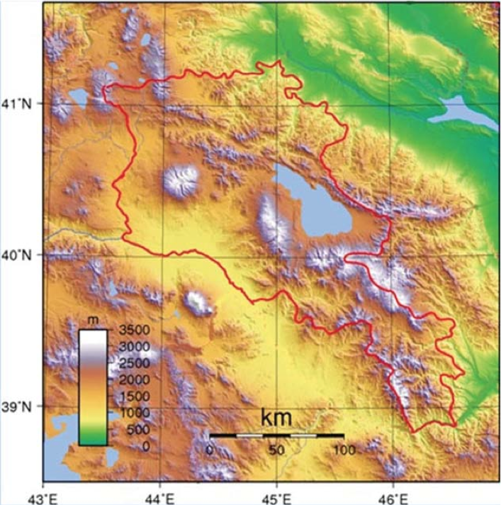
General information on the Republic of Armenia - Հայաստանի Հանրապետություն (Hayastani Hanrapetutyun)
| Form of government | Republic |
| Capital | Yerevan (1,066,300) |
| Independent since | September, 21st, 1991 (national holiday) |
| Oficial language | Armenian |
| Territory | 29,743 km2 |
| Population (January 1st, 2013) | 3,0269,00 |
| Population density/km2 | 102 |
| Highest elevation | Mount Aragatz, 4,090 metres |
| Longest river | Araks (192 km) |
| Neighboring countries | Georgia (North), Azerbaijan (East), Turkey (West and Southwest), Iran (South) |
All data and maps of this section are taken from the Statistical Yearbook of Armenia 2013 (http://www.armstat.am/en/?nid=45)
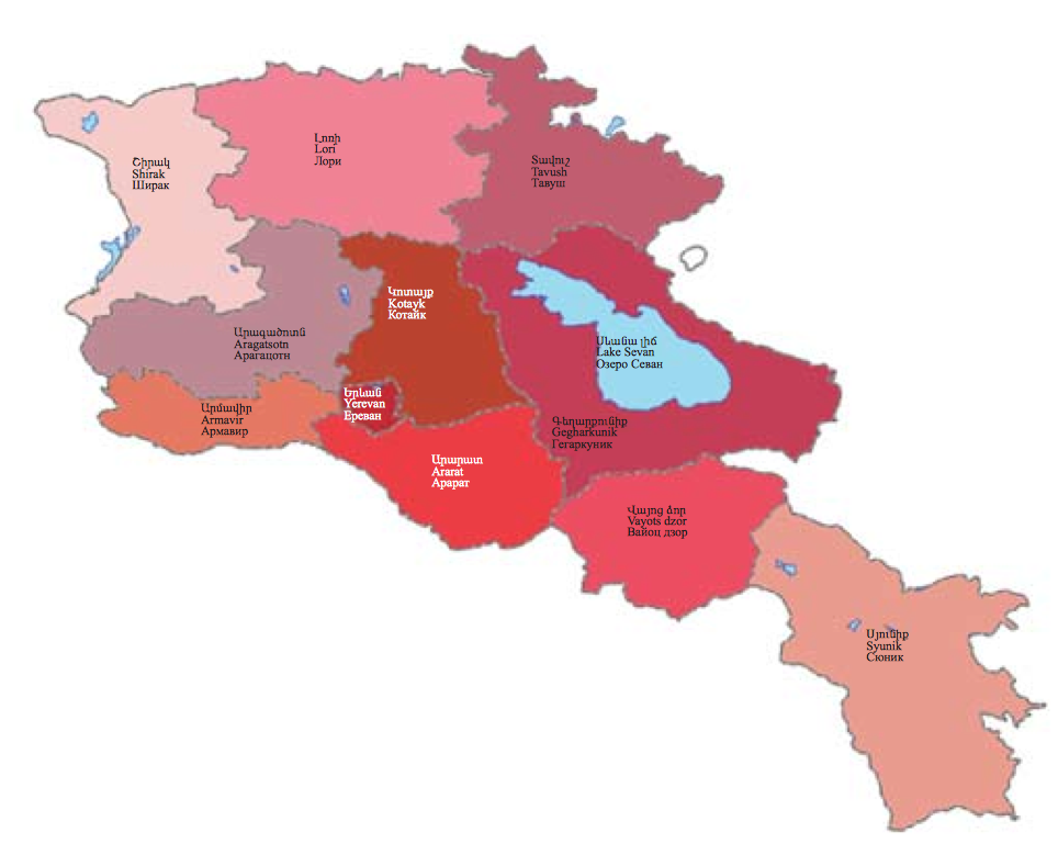
The Republic of Armenia is divided into ten territorial-administrative divisions (marzes) and the city of Yerevan:
| Marz | Territory km2 | Population | Population density/km2 |
| Yerevan city | 233 | 1,066,300 | 4,782 |
| Aragatsotn | 2756 | 133,000 | 48 |
| Ararat | 2090 | 261,400 | 125 |
| Armavir | 1242 | 267,100 | 215 |
| Gegharkunik | 5349 | 235,600 |
44 |
| Kotayk | 2086 | 255,300 | 122 |
| Lory | 3799 | 234,700 | 62 |
| Shirak | 2680 | 251,300 | 94 |
| Syunik | 4506 | 141,700 | 31 |
| Tawush | 2704 | 128,300 | 47 |
| Vayots dzor | 2308 | 52,200 | 23 |
All data and maps of this section are taken from the Statistical Yearbook of Armenia 2013 (http://www.armstat.am/en/?nid=45)
The following table shows the development of the different ethnic groups in Armenia as published in the results of the censuses of 2001 and 2002, the differences showing development trends have been calculated independently. Numbers of groups showing an asterisk (*) were not published as individual data in the census results. These figures are taken from fieldwork. Groups without any data do not appear in the census results and have not been surveyed yet.
| Ethnic group | 2011 census | 2001 census | Difference absolut | Difference in % |
| Total | 3,018,854 | 3,213,011 |
-194,157 |
-6.04 |
| Armenians (incl. Bosha) | 2,961,514 | 3,145,354 | -183,849 | -5.44 |
| Yezidis | 35,272 | 40,620 | -5,384 | -13.17 |
| Russians (incl. Molokans) | 11,862 | 14,660 | -2,798 | -19.09 |
| Assyrians | 2,769 | 3,409 | -640 | -18.77 |
| Kurds | 2,162 | 1,519 | +643 | +42.33 |
| Ukrainians | 1,176 | 1633 | -457 | -27.99 |
| Georgians | 974 | 696 | +278 | +39.94 |
| Greeks | 900 | 1,176 | -276 | -23.47 |
| Belorussians | n.d. | 257 | n.d. | n.d. |
| Germans* | 90 | n.d. | n.d. | n.d. |
| Poles* | n.d. | n.d. | n.d. | n.d. |
| Jews** | n.d. | ∼100 | n.d. | n.d. |
| Tatis* | n.d. | n.d. | n.d. | n.d. |
| Udis* | n.d. | n.d. | n.d. | n.d. |
** The data basis for determining the size of the Jewish community is problematic as a distinction has to made between the worldly and the religious community, both differing substantially in size and admission rules from each other (see entry). The value given refers to the information conveyed by religious community that is more clearly definable.
All data and maps of this section are taken from the censuses of the years 2001(for the complete census results see: http://docs.armstat.am/census/eng.php) and 2011(http://armstat.am/file/article/sv_03_13a_520.pdf, preliminary results only)
under construction